– Aerial wildlife survey methods have many advantages such as avoiding scaring off wild animals and avoiding double counting –
We interviewed S.Dorjderem, Principal Advisor Biodiversity for the Environmental department at Oyu Tolgoi LLC.
Your department has conducted an aerial survey of wildlife in the Gobi. What is the significance of this aerial survey? What was the objective of this work?
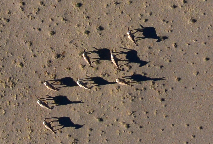
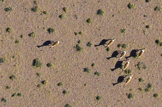
The objective was to determine the locations of wild animal habitats, to establish how many wild animals live there and what are the key adverse impacts on their lives. This information is essential for the development and implementation of the wildlife management plan. Now we can determine efficient measures to protect the wildlife. There are many ways to count wild animals and determine their distribution and habitat. The most advanced and costly method is through aerial survey. The aerial wildlife survey method has many advantages such as avoiding scaring off wild animals and avoiding double counting. We conducted an aerial survey of the wild ungulates in June and July this year. The survey covered an area of approximately 150,000 square km, including 11 soums throughout Umnugobi, Dornogobi and Dundgobi provinces. The main objective of the survey was to determine the distribution and population numbers of Mongolian wild ass, Khulan.
Have surveys of this kind been carried out in Mongolia before?
Previously, the aerial survey method was used to study wild antelope and Mongolian saiga. This current aerial survey, commissioned by Oyu Tolgoi, has the following advantages. Firstly, it covers a large area with much higher precision. Secondly, a land survey covering the same area was done at the same time. Thirdly, using the latest technology and equipment reduces the margin of error. We can say that this is the first time such a high precision aerial survey has been conducted in Mongolia.
 Wild sheep photo taken from the air |
How is this survey conducted? Can you explain the basics of the aerial survey?
In short, a plane flies along a straight line of the survey area and takes photos and makes recordings using infrared equipment to determine species and numbers of animals. The infrared records the body heat of the animals from the air. The plane flies along 122 straight lines, the distance between the lines is 5km, total length – 30,000km. The flight elevation was approximately 420m, flying speed 230 km/hour. We took photos using Nikon D00E camera with 7,360 х 4,912 pixel or 2.5 cm resolution and captured infrared images using FLIR P640 camera with 16cm pixel resolution and uploaded them to the 35TB Oyu Tolgoi database. Each image uploaded to the database was filtered using a computer programme and locations which radiated different temperatures from the environment were checked and counted manually.
How long was the flight duration each day? Did the weather impact the survey process?
We started very early morning before sunrise and took photos and recordings until 11 am. Otherwise, rocks and stones, heated by midday sun in the Gobi, would send false signals of 'wildlife'. The Oyu Tolgoi staff, Wildlife Conservation Society members and students of NUM are sorting and counting the wildlife images under the supervision of professor Howard. The students work under the careful guidance and instruction of the international experts leading the survey work. They are learning quickly and developing an eye for recognizing the animals including wild ass, black tail antelope, wild sheep, crane, birds of prey, livestock. We have recorded other wild animals which we don’t often see including foxes, wolves and corsac foxes. The five students working here filter about 500 images a day, counting the wild animals. This is the third month of the survey project, they are working with such energy and low error rate. These photos are then entered into a consolidated database linked with Geographic Information system or GIS. Therefore, when the survey finishes, it will be clear how many wild animals were in what location and habitat.
 Aerial photo of wild ass herd |
 Aerial photo of Mongolian gazelle herd |
Who is conducting the survey? What experience do they have?
A small team of world renowned specialists are working with Mongolians and successfully conducting the survey. The project leader is doctor Mike Norton Griff, a wildlife ecologist and world renowned specialist recognised for his aerial survey work. He has been working and living in the famous Serengeti National park in Kenya since 1969. Dana Slaymaker who works as a project technician is a US specialist in aerial observation flights and remote sensing. She has almost 30 years of fieldwork experience. She ensured reliability of the equipment and also worked as a copilot. Professor Howard Frederick is responsible for database development, the image recognition of wild animals and statistical processing. He also manages the team and the training of our Mongolian specialists and students. He is an experienced specialist who lives and works in Tanzania where he is developing wildlife aerial survey methodology and approaches, based on new technology.
What aircraft did you use for the survey?
We used a Pilatus PC-6 aircraft from Thomas Air company. About a dozen team members including pilots and a land support team flew safely for over 30,000km, overcoming the Gobi heat and competing against the time and successfully managing to avoid any delays. This is the most difficult job of the survey.
How do you plan to use the survey results?
The survey results, especially the database, can be used for many purposes. The photographic database can be used to study numbers and breeding of various wild animals, their distance from livestock herds, herders, infrastructure, settlement areas and their impacts on vegetation and pastureland conditions. The timing of aerial survey coincided with the foaling of the Khulan wild ass. It is also possible to continue the study of land use and land degradation of the surveyed area. The aerial survey was conducted simultaneously with the land based survey so the results of both methods can be compared and we will determine which method is more suitable for future surveys. This year, Oyu Tolgoi will put radio collars equipped with satellite transmitters and global positioning systems on 20 wild asses. Currently, only six wild asses have such radio collars. This method allows us to study the movements of the wild asses and see what factors affect and restrict their movements. The baseline data provided by the aerial survey will play a crucial role in this study.
Leave a Reply
You must be logged in to post a comment.